Sagarmatha National Park - Mount Everest & Sacred Mountain Adventure
NP
Where the earth tears upward through six thousand vertical meters of thin air, from the rhododendron forests of Monjo at 2,845 meters to the windswept summit of Mount Everest at 8,849 meters, Sagarmatha National Park commands the world's most extreme vertical ecosystem. Established on July 19, 1976, and inscribed as Nepal's first UNESCO World Heritage Site in 1979, this 1,148-square-kilometer wilderness encompasses not merely mountains but an entire civilization adapted to altitudes where most humans cannot breathe. Here, the Sherpa people have carved a culture from ice and stone, building villages, monasteries, and trading routes across landscapes that would crush lesser spirits.
The park's geography defies conventional understanding of what constitutes habitable terrain. Barren land above 5,000 meters comprises 69 percent of Sagarmatha, with another 28 percent devoted to high-altitude grazing lands where Himalayan tahr navigate cliff faces with supernatural agility. The remaining three percent of forested terrain clings to lower elevations, creating a compressed biological gradient unmatched anywhere on Earth. Within this vertical wilderness stand four peaks exceeding 8,000 meters—Everest itself, Lhotse, Cho Oyu, and the pyramid of Makalu—alongside dozens of lesser giants that would dominate any other mountain range. Ama Dablam, Thamserku, and Kongde Ri rise as sentinels above Sherpa settlements that have endured here for four centuries.
More than 6,000 Sherpas inhabit over 20 villages scattered across Sagarmatha's seemingly inhospitable terrain. Namche Bazaar, perched at 3,440 meters in an amphitheater carved by glacial forces, serves as the park's cultural and administrative capital where trekkers acclimatize in teahouses overlooking the Dudh Koshi Valley. Higher still, Khumjung and Khunde nestle at 3,790 meters beneath the shadow of Khumbila, the sacred peak that dominates Sherpa cosmology. Pangboche, at 3,900 meters, represents the last permanent settlement on the route to Everest Base Camp, its 350-year-old monastery standing as the Khumbu region's most ancient spiritual institution, founded by Lama Sangwa Dorjee and currently home to 20 resident monks. Tengboche, at 3,867 meters, anchors Sherpa religious life through Dawa Choling Gompa, the region's largest monastery, established in 1916 by Lama Gulu and rebuilt after devastating fires in 1934 and 1989. The village of Thame, gateway to the Nangpa La trading pass into Tibet, preserves traditions in relative isolation, while Phortse perches on a sun-drenched hillside, offering respite from the main trekking corridor.
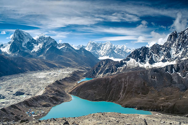
The classic Everest Base Camp trek spans 53 kilometers from Lukla's precipitous airstrip to the prayer-flag-draped moraine at 5,364 meters where mountaineering expeditions establish their staging camps. Trekkers push through Monjo, the official park entrance checkpoint, ascending through pine and rhododendron forests before emerging into Namche's warren of stone houses and vibrant market stalls. The trail climbs to Tengboche's monastery courtyard, where monks conduct ceremonies against a backdrop of Ama Dablam's hanging glaciers, then continues through Dingboche and Lobuche before the final push to Gorak Shep and Base Camp. The alternative Gokyo Lakes route diverges north of Namche, ascending through Dole and Machhermo to reach the turquoise waters of the world's highest freshwater lake system at 4,790 meters. This 112-kilometer circuit challenges trekkers with the Cho La Pass crossing at 5,420 meters, connecting the Gokyo Valley to the main Everest corridor via technical terrain that demands respect and preparation. Those who summit Kala Patthar at 5,555 meters earn Sagarmatha's ultimate reward: sunrise illuminating Everest's southwest face in shades of gold and crimson that no photograph can capture.
Wildlife adapted to these extreme altitudes includes species found nowhere else at such elevations. Snow leopards, locally extirpated in the early 1970s, have returned after nearly three decades of protection, now stalking prey between 3,000 and 5,400 meters. Himalayan tahr, the park's most abundant large mammal, graze across rocky slopes from 2,800 to 4,200 meters, their numbers sustaining the restored snow leopard population. Musk deer haunt rhododendron thickets at mid-elevations, their endangered status earning legal protection throughout Nepal. Red pandas, with their distinctive rust-colored fur and bushy tails, navigate high branches in lower forests, feeding on bamboo in an ecosystem that exists on the very edge of biological possibility. Himalayan black bears, common langur monkeys, and Himalayan serow complete this assembly of cold-adapted survivors.
Spring and autumn frame Sagarmatha's optimal trekking windows, each season offering distinct advantages. March through May transforms the park into a vertical garden as rhododendrons explode in crimson blooms across hillsides, with daytime temperatures reaching 7 degrees Celsius and nighttime lows dropping to minus 12. September through November delivers crystalline visibility and stable weather, with daytime warmth of 15 to 25 degrees offset by nights plunging to minus 10 at higher camps. Winter months—December through February—bring extreme cold with temperatures bottoming at minus 15 degrees, while monsoon season from June to September dumps 1,000 millimeters of precipitation across the region, turning trails into torrents and obscuring mountain views behind impenetrable clouds.
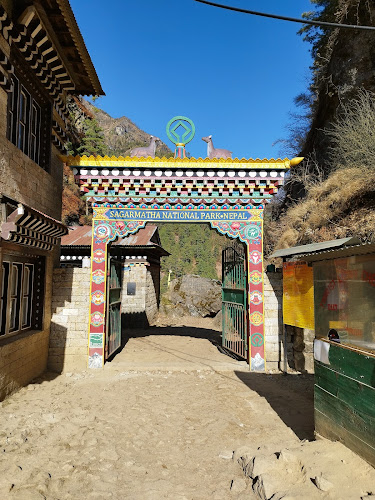
Access to Sagarmatha begins at Tenzing-Hillary Airport in Lukla, perched at 2,860 meters with a runway that drops away toward the Dudh Koshi gorge. Flights from Kathmandu span 30 to 45 minutes, though peak-season operations shift to Ramechhap, requiring a five-to-eight-hour drive followed by a 12-minute flight. Early morning departures between 6:00 and 10:00 AM maximize weather windows before afternoon clouds envelop the mountains. Alternative approaches from Jiri or Salleri extend the journey by several days, offering immersion in lower-elevation Sherpa culture absent from the Lukla route. Permits—the Sagarmatha National Park entry permit and Khumbu Pasang Lhamu Rural Municipality permit—can be obtained in Kathmandu, Lukla, or at the Monjo checkpoint itself.
This vertical wilderness represents more than spectacular scenery or mountaineering achievement. Sagarmatha preserves a complete cultural landscape where human adaptation to extreme environments has produced traditions, architecture, and spiritual practices uniquely suited to life at the roof of the world. The Mani Rimdu festival at Tengboche, sacred caves and hermitages scattered across high valleys, and the enduring hospitality of Sherpa families opening their homes to trekkers create an experience transcending mere adventure tourism. Here, geology and spirituality merge in an environment that strips away pretense and confronts visitors with both their limitations and their capacity for transcendence.
Park Features & Amenities
🏃 Activities
- ✓ Hiking
🏗️ Amenities
- ✓ Public toilet
🎠 Children
- ✓ Good for kids
- ✓ Kid-friendly hikes
🐕 Pets
- ✓ Dogs allowed
Visitor Information
🕐 Best Times to Visit
Spring (Mar-May): Pleasant weather, blooming flowers
Autumn (Sep-Nov): Clear skies, comfortable temperatures
Early Morning: Best for wildlife viewing and photography
🗺️ Getting There
By Car: Address available on contact
Public Transport: Local buses and taxis available
Walking: Check distance from city center
💡 Visitor Tips
• Bring water and sun protection
• Wear comfortable walking shoes
• Check weather conditions before visiting
• Bring camera for nature photography
Explore More in Nepal
Nearby Attractions
Popular Activities
Ready to Visit Sagarmatha National Park?
Plan your visit to this amazing destination with our comprehensive travel guide and insider tips.